By Edmond Ortiz
A local engineering firm has recommended installing warning lights and elevating part of a road where a flash flooding event last June led to the deaths of 11 people.
What you should know
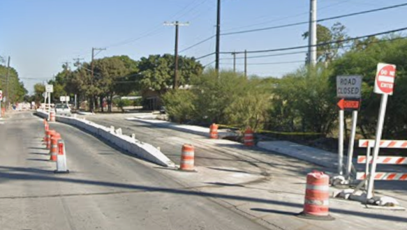
Justin Murray with the engineering company Kleinfelder briefed the City Council on Nov. 6 about the results of his firm’s investigation of June 12 event, where floodwaters in the 13-square-mile Beitel Creek watershed descended southward through Loop 410, and fast-moving waters swept away multiple occupied vehicles on the Northeast Side. The surging waters and debris also destroyed the Vicar Drive bridge at the creekway.
The height of the fatal incident happened after 4 a.m. during a storm that dumped more than 6 inches of rain on the area in a few hours. Not long afterward, the city dived into a post-incident analysis and engaged Kleinfelder’s services.
“This was a devastating event for our community, and we remain committed to understanding what happened and taking every possible step to reduce the probability of this occurring again,” City Manager Erik Walsh said.
Murray said the June 12 storm was the type that happens once every 25 years, with the most intense rainfall recorded on the northern stretch of the Beitel Creek watershed.
“The single biggest reason why the June 12 event happened was the rainfall,” he said.
According to Murray, the best models that existed before this storm did not accurately predict the depth or velocity of flood waters at the Loop 410 frontage roads.
The main reason behind the inaccuracy there, Murray said, is because of dense vegetation that covers undeveloped land along the westbound Loop 410 frontage roads immediately east of Perrin Beitel Road.
But Murray pointed to a stretch of westbound frontage road that sags below the surface of surrounding terrain, where the creekway meets the freeway, in the same exact area. He said the sagging segment of roadway is vulnerable to 25-year rain events, and as such, dangerous conditions quickly developed in that immediate overnight area.
Additionally, Murray said none of the road construction taking place along Interstate 35 played a significant part in the conditions that led to the creek waters topping the road surfaces along Loop 410.

What is next
Kleinfelder recommended the following potential solutions to decrease the flood risk in the area, including:
*The city work with the Texas Department of Transportation to install flashing lights and warnings at the sag point and at the Austin Highway underpass, a key point where motorists unknowingly entered the flash flood zone on the early morning of June 12. City officials said they are already coordinating with TxDOT to install the warning lights. TxDOT has already installed a high water warning sign.
*The city and TxDOT begin long-term planning toward removing the Loop 410 frontage roads from the Beitel Creek floodplain.
*Enhance unified emergency protocols that will connect TxDOT, TransGuide, and the city’s public works and first responder departments when triggering road closures and public alerts. City officials said work here is already starting up.
*Upgrade and relocate sensors, such as rain gauges, automatic barriers and cameras, and integrate such resources with predictive modeling tools to improve early flood warning detection across the San Antonio area. City officials said this will happen in coordination with the TxDOT, Bexar County and San Antonio River Authority.
*Update existing flood models to incorporate 2D hydraulic modeling and existing land uses and presence of vegetation in a specific area.
*Clarify maintenance duties and manage vegetation along Beitel Creek. City officials said they have already crafted a vegetation management contract and schedule with the respective property owners in the area.
Mayor Gina Ortiz Jones praised the consulting engineers for their work, and lauded city staff for quickly commissioning an analysis of the deadly flood event, and for instantly starting work on solutions at a local level.
“There is continued interest from this body to make sure we understand the timeline and the costs associated (with solutions),” Jones said. “Not all of these things are within the city’s control, so we understand there’s much-needed partnership.”