By Edmond Ortiz
San Antonio can diversify its housing options with a focus on empty or underdeveloped parcels, future transportation, and more mixed-use development along commercial routes.
These and other suggestions are offered in a new Central Library exhibit that is the result of a year-long study performed by architecture, planning and design faculty and students at the University of Texas at San Antonio.
What you should know
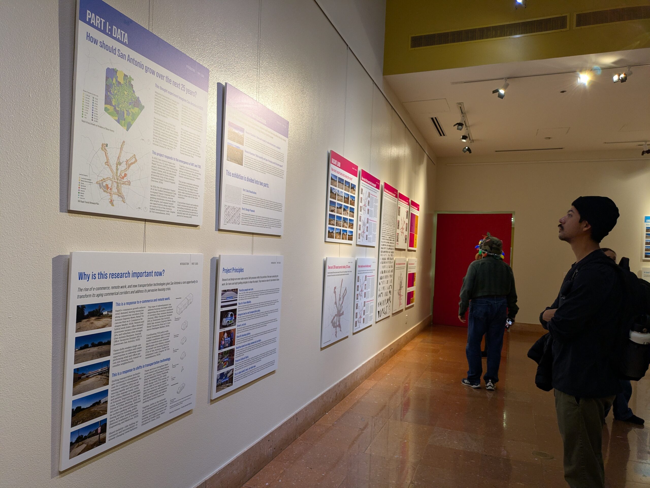
The exhibit, “Vacancy to Vitality: Exploring Housing Futures Along San Antonio’s Transit Corridors,” opened Dec. 9 at the Central Library gallery, 600 Soledad St. The study and resulting exhibit was organized by the UTSA Center for Urban and Regional Planning Research.
The opening reception included a panel discussion involving a team of experts who sought to identify potential solutions to a challenge where the city must provide new housing for 600,000-plus newcomers who are estimated to move into town by 2050.
Based on analyses of land along VIA Metropolitan Transit’s existing corridors, and proposed rapid transit corridors, the “Vacancy to Vitality” exhibit features maps, data visualizations, and housing design prototypes that reimagine long-established commercial corridors as vibrant neighborhoods.
Michelangelo Sabatino, director of the UTSA College of Architecture and Planning, said none of the ideas offered in the new exhibit are brand new, but rather the possible solutions are presented in such a way to advance and bring attention to updated data and existing concepts, which could help to remake San Antonio’s housing landscape.
Ian Caine, associate professor of architecture and planning, said four trends are driving the search for enhanced, long-term housing solutions in San Antonio: the city’s growth, the emergence of transit-oriented zoning, the arrival of rapid mass transit and new transportation options, such as rideshares and autonomous vehicles, and how businesses are now leaning more on e-commerce and remote work rather than traditional brick-and-mortar shops or office campuses.
In terms of advanced rapid transit (ART), VIA is developing north-south and east-west corridors in the heart of San Antonio that will contain dedicated bus lanes, frequent pickups and dropoffs, among other amenities.
“We’re imagining a future where private, gas-powered cars and large surface parking lots become less important and maybe eventually obsolete,” Caine said.
The idea here, Caine said, is that local individuals, businesses and government officials will have a shift in their collective mindset about neighborhoods making more walkable, more amenable to public mass transit, and redeveloping abandoned or underused commercial lots for a wider array of housing rather than continuing outward urban sprawl.
“Our point of view is that we want to prioritize people over cars. We want to plan for new mobility scenarios beyond cars,” Caine said. “From integrated land use and transportation policy standpoint, we’re interested in infilling and growing up, and not growing out. We’re interested in diversifying people’s housing options. There’s too much single-family housing, not enough housing for multi-generational, single-parent families. Non-traditional families need to have more options.
Caine continued: “We’re not talking about knocking down buildings and businesses, we want to try and figure out how to infill and build in and around businesses and culture that are already there.”
A closer look
The exhibit contains multiple key findings from the research team:
*Many neighborhoods on the older West and East sides have the highest levels of socioeconomic inequity in San Antonio;
*The highest amounts of neighborhood change, such as gentrification, exist on the inner East Side, along major corridors inside Loop 410 and north of downtown, and in various parts of the South Side;
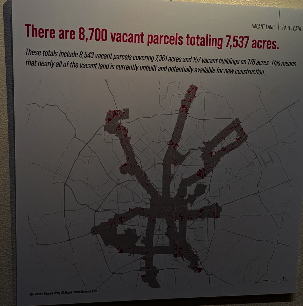
*San Antonio has more than 8,500 vacant parcels covering 7,361 acres, and 157 vacant structures on 176 acres, meaning nearly all of the city’s currently vacant land is unbuilt and potentially available for new construction;
The research team offered some exclusionary recommendations:
*Do not build housing on parcels with a land to improvement ratio above 1.0 as they are plots less valuable than existing structures that they accommodate. Such parcels, researchers said, are more costly and difficult to redevelop.
*Do not build housing on parcels owned by nonprofits or educational institutions because redeveloping such plots typically involves lengthy legal, political and organizational processes.
*Do not build housing in floodplains or on undersized parcels due to high costs, potential liabilities or ownership constraints.
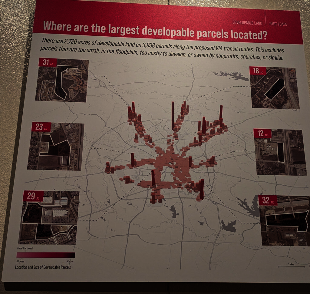
Having accounted for exclusionary data points, the researchers said 2,720 acres of developable land on 3,938 parcels exist along proposed VIA rapid transit routes; many of the largest vacant parcels lie in clusters between seven and 15 miles from the center of San Antonio.
Most of the developable acres – 2,359 to be exact – are owned by private companies. One-third of developable acreage in town sit within medium or large parcels, according to the researchers.
Final conclusions
Using various tools, the UTSA research team found that most small to midsized occupied commercial parcels, such as those with convenience stores, might be better suited to switch zoning and accommodate the appropriate type of housing.
The researchers suggested that, in order to maximize developmental potential in select spots around town, a significant reduction in parking space, especially surface lots. According to the team’s findings, San Antonio has 877,500-plus parking spaces sitting along proposed advanced rapid transit paths. The city’s total parking space supply exceeds the average ratio of three parking spaces per 1,000 ground square footage of commercial space by 200%.
The researchers said they are wary that even well-intentioned newer residential developments can displace residents in older neighborhoods. The recommended reducing neighborhoods’ displacement risk level by adding new policies or beefing up existing policies, such as requiring affordability commitments from developers, and mandating inclusionary zoning along VIA corridors to ensure housing for people earning 30% to 60% of the average median income.
Additionally, the exhibit identifies select types of infill residential strategies, such as live-work lanes, “almost home” townhomes, tiny home villages, and living loops that could possibly fit within existing vacant or underutilized commercial spaces, such as bungalow strips roadside motels, office parks, “little” retail big boxes, and regional malls.
The researchers and panelists at the Dec. 9 event agreed that, in order to get to this point years from now, local political leaders need the willpower to advance supportive changes in zoning and mass transit, and offer incentives that developers could find amenable.
The speakers also said it will take lots of visioning and foresight for all community members.
Christine Vina, VIA’s project manager, said people must challenge themselves to envision different possibilities, but simultaneously work towards not disrupting the longstanding culture of neighborhoods and businesses.
“You really have to meet folks on their terms at their convenience,” Vina said. “It is really hard to run businesses in this world today, and so to the extent that we can be accommodating them, especially small businesses, it’s really important to start that dialogue to be able to build trust with businesses because there are a lot of folks that want to be engaged, but they simply can’t do it if it’s structured environment.
Jim Bailey, senior principal at Alamo Architects, suggested it could mean getting locals out of their comfort zone.
“Walk around your neighborhood and give transit a try. See your city through new eyes,” Bailey said.
“Vacancy to Vitality” exhibit continues through Jan. 10 at the Central Library gallery on the first floor. Admission is free; up to three hours of garage parking are available through ticket validation.